Middle East 1945.jpg
Item
image/jpeg · 1.5 MB
원문 파일은 공개 웹에서 바로 열리지 않습니다. 열람 또는 제공이 필요한 경우 자료 신청을 해 주세요.

- Title
- Middle East 1945.jpg
- Description
-
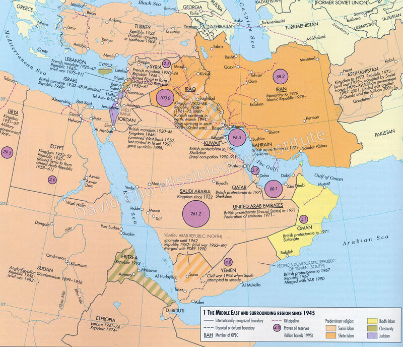
요약 (KO): 「1945년 이후 중동과 주변 지역」이라는 제목의 지도를 촬영한 이미지다. 중동 각국의 국경과 주요 도시, 독립·정체 변화의 연혁, 주요 종교 분포, 송유관과 1995년 기준 확인 석유 매장량을 함께 표시한다.
Summary (EN): This image reproduces a map titled The Middle East and Surrounding Region Since 1945. It marks national boundaries and major cities, historical changes in government, predominant religions, oil pipelines, and proven oil reserves measured in 1995. - Identifier
- ewc:s3:c745902e0b72b04ff8e15af45d7b1a8e5b422e49
- Is Part Of
- 02_AMA/CONVENTIONS/General Councils/PHOTOS
- Format
- jpg
- Extent
- 1570671 bytes
- Item sets
- 02 AMA
- Media
 Middle East 1945.jpg